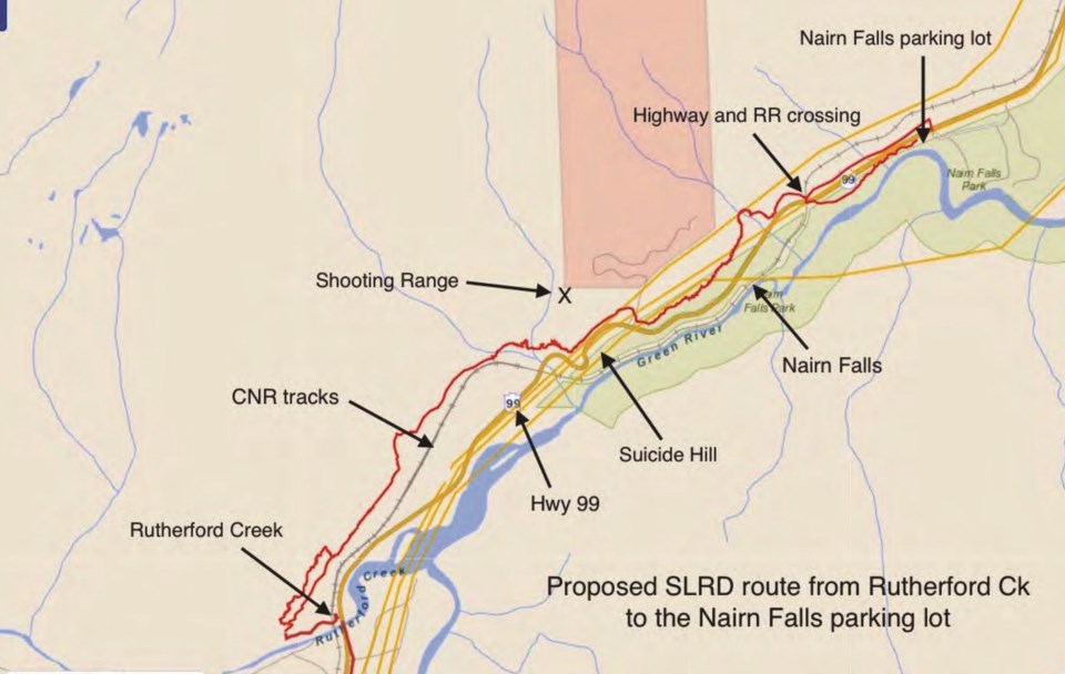
Despite appeals from some local hiking enthusiasts, the Squamish-Lillooet Regional District (SLRD) will not shift course on its preferred route for the final connection of the Sea to Sky Trail between Whistler and Pemberton.
On Oct. 26, the SLRD board voted unanimously to continue with its original plan to construct the route—from Gord’s Garden (north of Shadow Lake) to Nairn Falls Provincial Park—on the west side of Highway 99.
Detractors had previously pointed out that the proposed route passes Suicide Hill, the Pemberton Speedway, a gun range and active industrial operations, and poses some safety issues at river crossings.
But SLRD staff noted in a report to the board that work to complete the connection has been ongoing since 2012, with the original route picked several years ago.
The SLRD’s preferred route has nearly completed all stakeholder engagement and permitting processes, with funding secured for trail construction in 2023.
If the district were to change course, and go with a different route being proposed by some hikers, the SLRD would need to go back to the drawing board on consultation, said SLRD project manager Samuel Thompson, in a presentation to the board.
“We’d have to begin new stakeholder engagement and permit applications for Route B; the timeline for that would likely be six to 12 months,” he said.
“With regards to [a proposed bridge crossing], we would require approval of 小蓝视频 Parks, and have to have that surveying and engineering done prior to approval. So we’re saying it would probably be a minimum of 12 months to get all of the approvals in place for the secondary route.”
The estimated cost to complete the remaining eight kilometres of trail between Pemberton and Whistler is $450,000 to $500,000. The SLRD based the estimate on comparable trail projects (while also factoring in inflation).
The alternate route in question, on the eastside of Highway 99, was floated by a group of hiking enthusiasts called the Citizens for the Sea to Sky Trail earlier this fall.
The route would follow an abandoned logging road along the base of Mount Currie, up a medium-sized hill before dropping down to the edge of Green River. Once at the river’s edge, the trail would hug the cliffside before crossing over a bridge at the popular Nairn Falls, connecting to the rest of the existing trail network.
Proponents argued the route would follow a quieter, less industrial path than the current plan, as it would avoid the Pemberton Speedway, Sea to Sky Soils, the CN Railway and Highway 99.
The proposal would bear a similar cost, but building the new bridge at the waterfall and doing more consultation would add unknown expenses and delays to the trail’s construction.
While the eastside proposal is attractive, it may have come too late in the trail- building process, as Route A was identified in the Sea to Sky Trail Master Plan as the preferred route several years ago.
“The other route looks beautiful, but I think some of those challenges, the bridge in particular, and the cultural considerations mean it will be a very long and expensive process,” said Area B Director Vivian Birch-Jones.
“I think we should proceed with Plan A, and I appreciate the other trail, and they should also proceed, but not necessarily on our dime or with our involvement.”
Area C Director Russell Mack noted the proposed alternate trail could avoid a new bridge altogether by extending to the Green River crossing, which connects the Pemberton Airport road to the base of Mount Currie.
That alternate route could eventually be built as part of the Sea to Sky Trail, in addition to Route A, sometime in the future, SLRD staff noted. However, staff added that this course would require more consultation, and would cross through wetlands and wildlife habitats.
The SLRD estimates construction on the final section of the Sea to Sky trail to Pemberton will begin sometime in 2023.


